一、簡介
1.在移動互聯網時代,移動app能解決用戶的很多生活瑣事,比如
(1)導航:去任意陌生的地方
(2)周邊:找餐館、找酒店、找銀行、找電影院
2.在上述應用中,都用到了地圖和定位功能,在iOS開發中,要想加入這2大功能,必須基于2個框架進行開發
(1)Map Kit :用于地圖展示
(2)Core Location :用于地理定位
3.兩個熱門專業術語
(1)LBS :Location Based Service(基于定位的服務)
(2)SoLoMo :Social Local Mobile(索羅門)
二、CoreLocation框架的使用
1.CoreLocation框架使用前提
(1)導入框架

說明:在Xcode5以后,不再需要我們手動導入
(2)導入主頭文件
2.CoreLocation框架使用須知
CoreLocation框架中所有數據類型的前綴都是CL
CoreLocation中使用CLLocationManager對象來做用戶定位
三、經緯度等地理信息掃盲
1.示意圖

2.本初子午線:穿過英國倫敦格林文治天文臺
往東邊(右邊)走,是東經(E)
往西邊(左邊)走,是西經(W)
東西經各180°,總共360°
3.赤道:零度維度
往北邊(上邊)走,是北緯(N)
往南邊(下邊)走,是南緯(S)
南北緯各90°,總共180°
提示:橫跨經度/緯度越大(1° ≈ 111km),表示的范圍就越大,在地圖上看到的東西就越小
4.我國的經緯度:
(1)中國的經緯度范圍
緯度范圍:N 3°51′ ~ N 53°33′
經度范圍:E 73°33′ ~ E 135°05′
(2)部分城市的經緯度

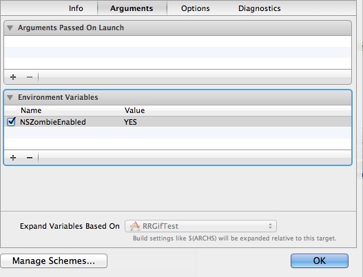
四、模擬位置
說明:在對程序進行測試的時候,設置手機模擬器的模擬位置(經緯度)


CoreLocation地理編碼
一、簡單說明
CLGeocoder:地理編碼器,其中Geo是地理的英文單詞Geography的簡寫。
1.使用CLGeocoder可以完成“地理編碼”和“反地理編碼”
地理編碼:根據給定的地名,獲得具體的位置信息(比如經緯度、地址的全稱等)
反地理編碼:根據給定的經緯度,獲得具體的位置信息
(1)地理編碼方法
當地理/反地理編碼完成時,就會調用CLGeocodeCompletionHandler

這個block傳遞2個參數
error :當編碼出錯時(比如編碼不出具體的信息)有值
placemarks :里面裝著CLPlacemark對象
3.CLPlacemark
說明:CLPlacemark的字面意思是地標,封裝詳細的地址位置信息
地理位置 @property (nonatomic, readonly) CLLocation *location;
區域 @property (nonatomic, readonly) CLRegion *region;
詳細的地址信息 @property (nonatomic, readonly) NSDictionary *addressDictionary;
地址名稱 @property (nonatomic, readonly) NSString *name;
城市 @property (nonatomic, readonly) NSString *locality;
二、代碼示例:
在storyboard中搭建界面如下:

實現代碼:
#import "YYViewController.h"
#import <CoreLocation/CoreLocation.h>
@interface YYViewController ()
@property(nonatomic,strong)CLGeocoder *geocoder;
#pragma mark-地理編碼
- (IBAction)geocode;
@property (weak, nonatomic) IBOutlet UITextField *addressField;
@property (weak, nonatomic) IBOutlet UILabel *longitudeLabel;
@property (weak, nonatomic) IBOutlet UILabel *latitudeLabel;
@property (weak, nonatomic) IBOutlet UILabel *detailAddressLabel;
#pragma mark-反地理編碼
- (IBAction)reverseGeocode;
@property (weak, nonatomic) IBOutlet UITextField *longitudeField;
@property (weak, nonatomic) IBOutlet UITextField *latitudeField;
@property (weak, nonatomic) IBOutlet UILabel *reverdeDetailAddressLabel;
@end
#pragma mark-懶加載
-(CLGeocoder *)geocoder
{
if (_geocoder==nil) {
_geocoder=[[CLGeocoder alloc]init];
}
return _geocoder;
}
- (void)viewDidLoad
{
[super viewDidLoad];
}
/**
* 地理編碼:地名―>經緯度坐標
*/
- (IBAction)geocode {
//1.獲得輸入的地址
NSString *address=self.addressField.text;
if (address.length==0) return;
//2.開始地理編碼
//說明:調用下面的方法開始編碼,不管編碼是成功還是失敗都會調用block中的方法
[self.geocoder geocodeAddressString:address completionHandler:^(NSArray *placemarks, NSError *error) {
//如果有錯誤信息,或者是數組中獲取的地名元素數量為0,那么說明沒有找到
if (error || placemarks.count==0) {
self.detailAddressLabel.text=@"你輸入的地址沒找到,可能在月球上";
}else // 編碼成功,找到了具體的位置信息
{
//打印查看找到的所有的位置信息
/*
name:名稱
locality:城市
country:國家
postalCode:郵政編碼
*/
for (CLPlacemark *placemark in placemarks) {
NSLog(@"name=%@ locality=%@ country=%@ postalCode=%@",placemark.name,placemark.locality,placemark.country,placemark.postalCode);
}
//取出獲取的地理信息數組中的第一個顯示在界面上
CLPlacemark *firstPlacemark=[placemarks firstObject];
//詳細地址名稱
self.detailAddressLabel.text=firstPlacemark.name;
//緯度
CLLocationDegrees latitude=firstPlacemark.location.coordinate.latitude;
//經度
CLLocationDegrees longitude=firstPlacemark.location.coordinate.longitude;
self.latitudeLabel.text=[NSString stringWithFormat:@"%.2f",latitude];
self.longitudeLabel.text=[NSString stringWithFormat:@"%.2f",longitude];
}
}];
}
/**
* 反地理編碼:經緯度坐標―>地名
*/
- (IBAction)reverseGeocode {
//1.獲得輸入的經緯度
NSString *longtitudeText=self.longitudeField.text;
NSString *latitudeText=self.latitudeField.text;
if (longtitudeText.length==0||latitudeText.length==0) return;
CLLocationDegrees latitude=[latitudeText doubleValue];
CLLocationDegrees longitude=[longtitudeText doubleValue];
CLLocation *location=[[CLLocation alloc]initWithLatitude:latitude longitude:longitude];
//2.反地理編碼
[self.geocoder reverseGeocodeLocation:location completionHandler:^(NSArray *placemarks, NSError *error) {
if (error||placemarks.count==0) {
self.reverdeDetailAddressLabel.text=@"你輸入的地址沒找到,可能在月球上";
}else//編碼成功
{
//顯示最前面的地標信息
CLPlacemark *firstPlacemark=[placemarks firstObject];
self.reverdeDetailAddressLabel.text=firstPlacemark.name;
//經緯度
CLLocationDegrees latitude=firstPlacemark.location.coordinate.latitude;
CLLocationDegrees longitude=firstPlacemark.location.coordinate.longitude;
self.latitudeField.text=[NSString stringWithFormat:@"%.2f",latitude];
self.longitudeField.text=[NSString stringWithFormat:@"%.2f",longitude];
}
}];
}
-(void)touchesBegan:(NSSet *)touches withEvent:(UIEvent *)event
{
[self.view endEditing:YES];
}
@end
(1)地理編碼:(地名->經緯度坐標)

打印輸出:

(2)反地理編碼:(經緯度―>地名)

(3)注意:調整鍵盤

點擊經緯度textField進行輸入的時候,彈出的鍵盤如下

(4)注意:搜索的所有結果都是在中國境內的,因為蘋果在中國的地圖服務商是高德地圖。
新聞熱點


疑難解答