一、自定義大頭針和氣泡
// 根據(jù)anntation生成對應的View - (BMKAnnotationView *)mapView:(BMKMapView *)mapView viewForAnnotation:(id <BMKAnnotation>)annotation { NSString *AnnotationViewID = [NSString stringWithFormat:@"renameMark%d",i]; newAnnotation = [[BMKPinAnnotationView alloc] initWithAnnotation:annotation reuseIdentifier:AnnotationViewID]; // 設置顏色 ((BMKPinAnnotationView*)newAnnotation).pinColor = BMKPinAnnotationColorPurple; // 從天上掉下效果 ((BMKPinAnnotationView*)newAnnotation).animatesDrop = YES; // 設置可拖拽 ((BMKPinAnnotationView*)newAnnotation).draggable = YES; //設置大頭針圖標 ((BMKPinAnnotationView*)newAnnotation).image = [UIImage imageNamed:@"zhaohuoche"]; UIView *popView = [[UIView alloc]initWithFrame:CGRectMake(0, 0, 100, 60)]; //設置彈出氣泡圖片 UIImageView *image = [[UIImageView alloc]initWithImage:[UIImage imageNamed:@"wenzi"]]; image.frame = CGRectMake(0, 0, 100, 60); [popView addSubview:image]; //自定義顯示的內(nèi)容 UILabel *driverName = [[UILabel alloc]initWithFrame:CGRectMake(0, 3, 100, 20)]; driverName.text = @"張XX師傅"; driverName.backgroundColor = [UIColor clearColor]; driverName.font = [UIFont systemFontOfSize:14]; driverName.textColor = [UIColor whiteColor]; driverName.textAlignment = NSTextAlignmentCenter; [popView addSubview:driverName]; UILabel *carName = [[UILabel alloc]initWithFrame:CGRectMake(0, 25, 100, 20)]; carName.text = @"京A123456"; carName.backgroundColor = [UIColor clearColor]; carName.font = [UIFont systemFontOfSize:14]; carName.textColor = [UIColor whiteColor]; carName.textAlignment = NSTextAlignmentCenter; [popView addSubview:carName]; BMKActionPaopaoView *pView = [[BMKActionPaopaoView alloc]initWithCustomView:popView]; pView.frame = CGRectMake(0, 0, 100, 60); ((BMKPinAnnotationView*)newAnnotation).paopaoView = nil; ((BMKPinAnnotationView*)newAnnotation).paopaoView = pView; i++; return newAnnotation; } 二、氣泡自定義內(nèi)容
最簡單,最直接的方法。。。
自定義一個 UIView
核心代碼如下:
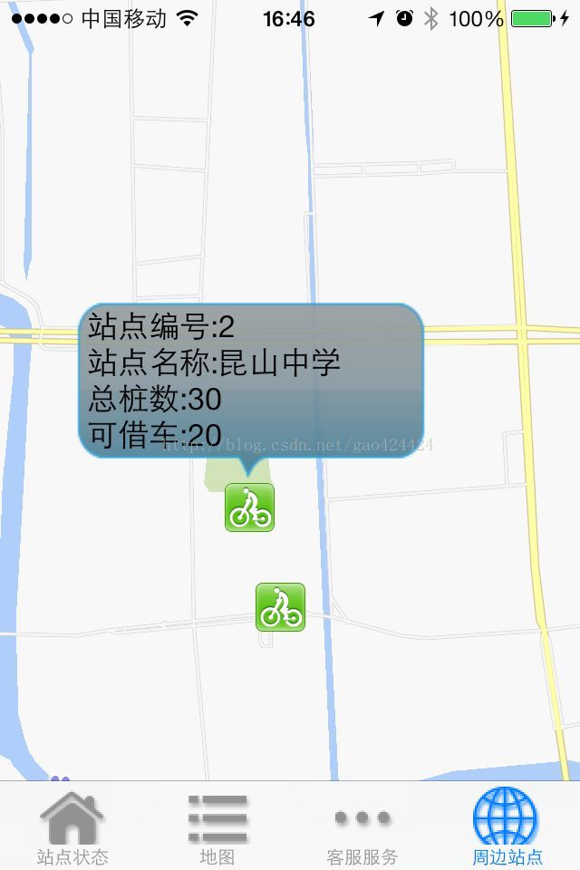
//改變標注圖片和自定義氣泡-(BMKAnnotationView *)mapView:(BMKMapView *)mapView viewForAnnotation:(id<BMKAnnotation>)annotation{ BMKAnnotationView *annotationView=[[BMKAnnotationViewalloc]initWithAnnotation:annotationreuseIdentifier:@"myAnnotation"]; annotationView.image =[UIImageimageNamed:@"bike.gif"]; //自定義內(nèi)容氣泡 UIView *areaPaoView=[[UIViewalloc]initWithFrame:CGRectMake(0, 0, 200, 100)]; areaPaoView.layer.cornerRadius=8; areaPaoView.layer.masksToBounds=YES; areaPaoView.layer.contents =(id)[UIImageimageNamed:@"pao.png"].CGImage;//這張圖片是做好的透明 //areaPaoView.backgroundColor=[UIColor whiteColor]; if ([annotation.titleisEqualToString:@"1"]) { //假設title的標題為1,那么就把添加上這個自定義氣泡內(nèi)容 UILabel * labelNo = [[UILabelalloc]initWithFrame:CGRectMake(10, 0, 200, 30)]; labelNo.text =[NSStringstringWithFormat:@"站點編號:%@"]; labelNo.textColor = [UIColorblackColor]; labelNo.backgroundColor = [UIColorclearColor]; [areaPaoViewaddSubview:labelNo]; UILabel * labelStationName = [[UILabelalloc]initWithFrame:CGRectMake(10, 20, 200, 30)]; labelStationName.text = [NSStringstringWithFormat:@"站點名稱:昆山中學"]; labelStationName.textColor = [UIColorblackColor]; labelStationName.backgroundColor = [UIColorclearColor]; [areaPaoViewaddSubview:labelStationName]; UILabel * labelSumNum = [[UILabelalloc]initWithFrame:CGRectMake(10, 40, 200, 30)]; labelSumNum.text = [NSStringstringWithFormat:@"總樁數(shù):30"]; labelSumNum.textColor = [UIColorblackColor]; labelSumNum.backgroundColor = [UIColorclearColor]; [areaPaoViewaddSubview:labelSumNum]; UILabel * labelBicycleNum = [[UILabelalloc]initWithFrame:CGRectMake(10, 60, 200, 30)]; labelBicycleNum.text = [NSStringstringWithFormat:@"可借車:20"]; labelBicycleNum.textColor = [UIColorblackColor]; labelBicycleNum.backgroundColor = [UIColorclearColor]; [areaPaoViewaddSubview:labelBicycleNum]; } BMKActionPaopaoView *paopao=[[BMKActionPaopaoViewalloc]initWithCustomView:areaPaoView]; annotationView.paopaoView=paopao; return annotationView;}三、添加標注自定義氣泡
1.首先實現(xiàn)添加多個標注和自定義氣泡
添加自定義標注
[_mapView addAnnotations:array];
arry 中放入標注(BMKPointAnnotation)的數(shù)組,此方法添加多個標注。
當添加多個標注時就觸發(fā)以下代理方法
#pragma mark -- BMKMapdelegate/** *根據(jù)anntation生成對應的View *@param mapView 地圖View *@param annotation 指定的標注 *@return 生成的標注View */-(BMKAnnotationView *)mapView:(BMKMapView *)mapView viewForAnnotation:(id <BMKAnnotation>)annotation{ if ([annotation isKindOfClass:[BMKPointAnnotation class]]) { BMKPinAnnotationView *newAnnotationView = [[BMKPinAnnotationView alloc]initWithAnnotation:annotation reuseIdentifier:@"myAnnotation"]; newAnnotationView.animatesDrop = YES; newAnnotationView.annotation = annotation; //這里我根據(jù)自己需要,繼承了BMKPointAnnotation,添加了標注的類型等需要的信息 MyBMKPointAnnotation *tt = (MyBMKPointAnnotation *)annotation; //判斷類別,需要添加不同類別,來賦予不同的標注圖片 if (tt.profNumber == 100000) { newAnnotationView.image = [UIImage imageNamed:@"ic_map_mode_category_merchants_normal.png"]; }else if (tt.profNumber == 100001){ } //設定popView的高度,根據(jù)是否含有縮略圖 double popViewH = 60; if (annotation.subtitle == nil) { popViewH = 38; } UIView *popView = [[UIView alloc]initWithFrame:CGRectMake(0, 0, ScreenWidth-100, popViewH)]; popView.backgroundColor = [UIColor whiteColor]; [popView.layer setMasksToBounds:YES]; [popView.layer setCornerRadius:3.0]; popView.alpha = 0.9;// //設置彈出氣泡圖片// UIImageView *image = [[UIImageView alloc]initWithImage:[UIImage imageNamed:tt.imgPath]];// image.frame = CGRectMake(0, 160, 50, 60);// [popView addSubview:image]; //自定義氣泡的內(nèi)容,添加子控件在popView上 UILabel *driverName = [[UILabel alloc]initWithFrame:CGRectMake(8, 4, 160, 30)]; driverName.text = annotation.title; driverName.numberOfLines = 0; driverName.backgroundColor = [UIColor clearColor]; driverName.font = [UIFont systemFontOfSize:15]; driverName.textColor = [UIColor blackColor]; driverName.textAlignment = NSTextAlignmentLeft; [popView addSubview:driverName]; UILabel *carName = [[UILabel alloc]initWithFrame:CGRectMake(8, 30, 180, 30)]; carName.text = annotation.subtitle; carName.backgroundColor = [UIColor clearColor]; carName.font = [UIFont systemFontOfSize:11]; carName.textColor = [UIColor lightGrayColor]; carName.textAlignment = NSTextAlignmentLeft; [popView addSubview:carName]; if (annotation.subtitle != nil) { UIButton *searchBn = [[UIButton alloc]initWithFrame:CGRectMake(170, 0, 50, 60)]; [searchBn setTitle:@"查看路線" forState:UIControlStateNormal]; searchBn.backgroundColor = mainColor; searchBn.titleLabel.numberOfLines = 0; [searchBn addTarget:self action:@selector(searchLine)]; [popView addSubview:searchBn]; } BMKActionPaopaoView *pView = [[BMKActionPaopaoView alloc]initWithCustomView:popView]; pView.frame = CGRectMake(0, 0, ScreenWidth-100, popViewH); ((BMKPinAnnotationView*)newAnnotationView).paopaoView = nil; ((BMKPinAnnotationView*)newAnnotationView).paopaoView = pView; return newAnnotationView; } return nil;}點擊標注和氣泡響應方法
/** * 當選中一個annotation views時,調(diào)用此接口 * @param mapView 地圖View * @param views 選中的annotation views */- (void)mapView:(BMKMapView *)mapView didSelectAnnotationView:(BMKAnnotationView *)view{ _shopCoor = view.annotation.coordinate;}/** * 選中氣泡調(diào)用方法 * @param mapView 地圖 * @param view annotation */- (void)mapView:(BMKMapView *)mapView annotationViewForBubble:(BMKAnnotationView *)view{ MyBMKPointAnnotation *tt = (MyBMKPointAnnotation *)view.annotation; if (tt.shopID) { BusinessIfonUVC *BusinessIfonVC = [[BusinessIfonUVC alloc]init]; BusinessIfonVC.shopId = tt.shopID; [self.navigationController pushViewController:BusinessIfonVC animated:YES]; }}2.實現(xiàn)路線搜索,路徑規(guī)劃,獲取街道名稱等功能
通過經(jīng)緯度獲取地址,逆地理編碼
-(void)getStartAddress{ //起點地址 CLGeocoder *Geocoder = [[CLGeocoder alloc]init]; CLGeocodeCompletionHandler handler = ^(NSArray *place,NSError *error){ for(CLPlacemark *placemark in place){ NSString *tmp = [[NSString alloc]init]; tmp = placemark.subThoroughfare; if (tmp == nil) { tmp = @""; } NSString *startAdr = [[NSString alloc]initWithFormat:@"%@%@",placemark.thoroughfare,tmp]; _startCityText.text = placemark.locality; if ([startAdr isEqualToString:@"(null)"]) { _startAddrText.text = @"獲取地址失敗"; }else{ _startAddrText.text = startAdr; } } }; CLLocation *loc = [[CLLocation alloc]initWithLatitude:self.startCoor.latitude longitude:self.startCoor.longitude]; [Geocoder reverseGeocodeLocation:loc completionHandler:handler];}路徑檢索,該部分沒有整理,將乘車和換乘信息放到了LineInfo,steps等模型中。
- (void)onGetTransitRouteResult:(BMKRouteSearch*)searcher result:(BMKTransitRouteResult*)result errorCode:(BMKSearchErrorCode)error{ NSMutableArray *lineArr = [[NSMutableArray alloc]init]; NSArray* array = [NSArray arrayWithArray:_mapView.annotations]; [_mapView removeAnnotations:array]; array = [NSArray arrayWithArray:_mapView.overlays]; [_mapView removeOverlays:array]; if (error == BMK_SEARCH_NO_ERROR) { for(int j = 0; j < [result.routes count];j++) { NSMutableArray *busTitleArr = [[NSMutableArray alloc]init]; NSMutableArray *lineStepsArr = [[NSMutableArray alloc]init]; NSMutableArray *stepsArr = [[NSMutableArray alloc]init]; //生成數(shù)據(jù)模型 LineInfoModel *lineInfo = [[LineInfoModel alloc]init]; BMKTransitRouteLine* plan = (BMKTransitRouteLine*)[result.routes objectAtIndex:j]; //數(shù)據(jù)模型:獲得路線長度 lineInfo.distance = plan.distance; //數(shù)據(jù)模型:獲得路線消耗時間 lineInfo.dates = plan.duration.dates; lineInfo.hours = plan.duration.hours; lineInfo.minutes = plan.duration.minutes; lineInfo.seconds = plan.duration.seconds; // 獲得軌跡點 lineInfo.planStepsArr = plan.steps; // 計算路線方案中的路段數(shù)目 int size = [plan.steps count]; int planPointCounts = 0; for (int i = 0; i < size; i++) { BMKTransitStep* transitStep = [plan.steps objectAtIndex:i]; //數(shù)據(jù)模型:獲得乘坐公交數(shù)組 DLog(@"%@",transitStep.vehicleInfo.title); if (transitStep.vehicleInfo.title) { [busTitleArr addObject:transitStep.vehicleInfo.title]; } //數(shù)據(jù)模型:獲取換乘信息 if (transitStep.instruction) { transitStep.instruction = [transitStep.instruction stringByReplacingOccurrencesOfString:@"<font color=/"#313233/">" withString:@""]; [lineStepsArr addObject:transitStep.instruction]; } DLog(@"%@ %@",transitStep.vehicleInfo.title,transitStep.instruction); if(i==0){ RouteAnnotation* item = [[RouteAnnotation alloc]init]; item.coordinate = plan.starting.location; item.title = @"起點"; item.type = 0;// [_mapView addAnnotation:item]; // 添加起點標注// // [stepsArr addObject:item]; }else if(i==size-1){ RouteAnnotation* item = [[RouteAnnotation alloc]init]; item.coordinate = plan.terminal.location; item.title = @"終點"; item.type = 1; [stepsArr addObject:item];// [_mapView addAnnotation:item]; // 添加起點標注// } RouteAnnotation* item = [[RouteAnnotation alloc]init]; item.coordinate = transitStep.entrace.location; item.title = transitStep.instruction; transitStep.instruction = [transitStep.instruction stringByReplacingOccurrencesOfString:@"<font color=/"#313233/">" withString:@""]; item.type = 3; [stepsArr addObject:item];// [_mapView addAnnotation:item];// // // //軌跡點總數(shù)累計 planPointCounts += transitStep.pointsCount; } lineInfo.vehicleInfoArr = busTitleArr; lineInfo.lineStepsArr = lineStepsArr; lineInfo.stepsArr = stepsArr; lineInfo.planPointCounts = planPointCounts; [lineArr addObject:lineInfo];// //軌跡點// BMKMapPoint * temppoints = new BMKMapPoint[planPointCounts];// int i = 0;// for (int j = 0; j < size; j++) {// BMKTransitStep* transitStep = [plan.steps objectAtIndex:j];// int k=0;// for(k=0;k<transitStep.pointsCount;k++) {// temppoints[i].x = transitStep.points[k].x;// temppoints[i].y = transitStep.points[k].y;// i++;// } } self.lineStatusArr = lineArr; // 通過points構(gòu)建BMKPolyline// BMKPolyline* polyLine = [BMKPolyline polylineWithPoints:temppoints count:planPointCounts];// [_mapView addOverlay:polyLine]; // 添加路線overlay// delete []temppoints;// } [_tableView reloadData]; }}- (void)onGetDrivingRouteResult:(BMKRouteSearch*)searcher result:(BMKDrivingRouteResult*)result errorCode:(BMKSearchErrorCode)error{ NSArray* array = [NSArray arrayWithArray:_mapView.annotations]; [_mapView removeAnnotations:array]; array = [NSArray arrayWithArray:_mapView.overlays]; [_mapView removeOverlays:array]; if (error == BMK_SEARCH_NO_ERROR) { BMKDrivingRouteLine* plan = (BMKDrivingRouteLine*)[result.routes objectAtIndex:0]; // 計算路線方案中的路段數(shù)目 int size = [plan.steps count]; int planPointCounts = 0; for (int i = 0; i < size; i++) { BMKDrivingStep* transitStep = [plan.steps objectAtIndex:i]; if(i==0){ RouteAnnotation* item = [[RouteAnnotation alloc]init]; item.coordinate = plan.starting.location; item.title = @"起點"; item.type = 0; [_mapView addAnnotation:item]; // 添加起點標注 }else if(i==size-1){ RouteAnnotation* item = [[RouteAnnotation alloc]init]; item.coordinate = plan.terminal.location; item.title = @"終點"; item.type = 1; [_mapView addAnnotation:item]; // 添加起點標注 } //添加annotation節(jié)點 RouteAnnotation* item = [[RouteAnnotation alloc]init]; item.coordinate = transitStep.entrace.location; item.title = transitStep.entraceInstruction; item.degree = transitStep.direction * 30; item.type = 4; [_mapView addAnnotation:item]; //軌跡點總數(shù)累計 planPointCounts += transitStep.pointsCount; } // 添加途經(jīng)點 if (plan.wayPoints) { for (BMKPlanNode* tempNode in plan.wayPoints) { RouteAnnotation* item = [[RouteAnnotation alloc]init]; item = [[RouteAnnotation alloc]init]; item.coordinate = tempNode.pt; item.type = 5; item.title = tempNode.name; [_mapView addAnnotation:item]; } } //軌跡點 BMKMapPoint * temppoints = new BMKMapPoint[planPointCounts]; int i = 0; for (int j = 0; j < size; j++) { BMKDrivingStep* transitStep = [plan.steps objectAtIndex:j]; int k=0; for(k=0;k<transitStep.pointsCount;k++) { temppoints[i].x = transitStep.points[k].x; temppoints[i].y = transitStep.points[k].y; i++; } } // 通過points構(gòu)建BMKPolyline BMKPolyline* polyLine = [BMKPolyline polylineWithPoints:temppoints count:planPointCounts]; [_mapView addOverlay:polyLine]; // 添加路線overlay delete []temppoints; }}- (void)onGetWalkingRouteResult:(BMKRouteSearch*)searcher result:(BMKWalkingRouteResult*)result errorCode:(BMKSearchErrorCode)error{ NSArray* array = [NSArray arrayWithArray:_mapView.annotations]; [_mapView removeAnnotations:array]; array = [NSArray arrayWithArray:_mapView.overlays]; [_mapView removeOverlays:array]; if (error == BMK_SEARCH_NO_ERROR) { BMKWalkingRouteLine* plan = (BMKWalkingRouteLine*)[result.routes objectAtIndex:0]; int size = [plan.steps count]; int planPointCounts = 0; for (int i = 0; i < size; i++) { BMKWalkingStep* transitStep = [plan.steps objectAtIndex:i]; if(i==0){ RouteAnnotation* item = [[RouteAnnotation alloc]init]; item.coordinate = plan.starting.location; item.title = @"起點"; item.type = 0; [_mapView addAnnotation:item]; // 添加起點標注 }else if(i==size-1){ RouteAnnotation* item = [[RouteAnnotation alloc]init]; item.coordinate = plan.terminal.location; item.title = @"終點"; item.type = 1; [_mapView addAnnotation:item]; // 添加起點標注 } //添加annotation節(jié)點 RouteAnnotation* item = [[RouteAnnotation alloc]init]; item.coordinate = transitStep.entrace.location; item.title = transitStep.entraceInstruction; item.degree = transitStep.direction * 30; item.type = 4; [_mapView addAnnotation:item]; //軌跡點總數(shù)累計 planPointCounts += transitStep.pointsCount; } //軌跡點 BMKMapPoint * temppoints = new BMKMapPoint[planPointCounts]; int i = 0; for (int j = 0; j < size; j++) { BMKWalkingStep* transitStep = [plan.steps objectAtIndex:j]; int k=0; for(k=0;k<transitStep.pointsCount;k++) { temppoints[i].x = transitStep.points[k].x; temppoints[i].y = transitStep.points[k].y; i++; } } // 通過points構(gòu)建BMKPolyline BMKPolyline* polyLine = [BMKPolyline polylineWithPoints:temppoints count:planPointCounts]; [_mapView addOverlay:polyLine]; // 添加路線overlay delete []temppoints; }}3.畫路徑
我這里實現(xiàn)是跳轉(zhuǎn)到另一個控制器中了,下面是他一些需要的數(shù)據(jù)
//路線長度@property (nonatomic,assign) int distance;//路線消耗時間@property (nonatomic,assign) int dates;@property (nonatomic,assign) int hours;@property (nonatomic,assign) int minutes;@property (nonatomic,assign) int seconds;//交通工具數(shù)組@property (nonatomic,strong) NSArray *vehicleInfoArr;//換乘信息@property (nonatomic,strong) NSArray *lineStepsArr;//節(jié)點@property (nonatomic,strong) NSArray *stepsArr;//軌跡點個數(shù)@property (nonatomic,assign) int planPointCounts;//軌跡點@property (nonatomic,strong) NSArray *planStepsArr;
接下來是畫路經(jīng),關(guān)于乘車數(shù)據(jù)的展示,就是一個tableview上添加了手勢,不做解釋。
-(void)drawMap{ BMKPointAnnotation* item = [[BMKPointAnnotation alloc]init]; item = [_lineInfo.stepsArr firstObject]; [_mapView setCenterCoordinate:item.coordinate]; [_mapView addAnnotations:_lineInfo.stepsArr]; BMKMapPoint* temppoints = (BMKMapPoint *)malloc(sizeof(CLLocationCoordinate2D) * _lineInfo.planPointCounts); int i = 0; for (int j = 0; j < [_lineInfo.planStepsArr count]; j++) { BMKTransitStep* transitStep = [_lineInfo.planStepsArr objectAtIndex:j]; int k=0; for(k=0;k<transitStep.pointsCount;k++) { temppoints[i].x = transitStep.points[k].x; temppoints[i].y = transitStep.points[k].y; i++; } } BMKPolyline* polyLine =[BMKPolyline polylineWithPoints:temppoints count:_lineInfo.planPointCounts]; if (nil != polyLine) { [_mapView addOverlay:polyLine]; // 添加路線overlay } free(temppoints);}- (BMKOverlayView*)mapView:(BMKMapView *)map viewForOverlay:(id<BMKOverlay>)overlay{ if ([overlay isKindOfClass:[BMKPolyline class]]) { BMKPolylineView* polylineView = [[BMKPolylineView alloc] initWithOverlay:overlay]; polylineView.fillColor = [[UIColor cyanColor] colorWithAlphaComponent:1]; polylineView.strokeColor = [[UIColor blueColor] colorWithAlphaComponent:0.7]; polylineView.lineWidth = 3.0; return polylineView; } return nil;}// 判斷標注類型,來處理- (BMKAnnotationView*)getRouteAnnotationView:(BMKMapView *)mapview viewForAnnotation:(MyBMKPointAnnotation*)routeAnnotation{ BMKAnnotationView* view = nil; switch (routeAnnotation.type) { case 0: { view = [mapview dequeueReusableAnnotationViewWithIdentifier:@"start_node"]; if (view == nil) { view = [[BMKAnnotationView alloc]initWithAnnotation:routeAnnotation reuseIdentifier:@"start_node"]; view.image = [UIImage imageWithContentsOfFile:[self getMyBundlePath1:@"images/icon_nav_start.png"]]; view.centerOffset = CGPointMake(0, -(view.frame.size.height * 0.5)); view.canShowCallout = TRUE; } view.annotation = routeAnnotation; } break; case 1: { view = [mapview dequeueReusableAnnotationViewWithIdentifier:@"end_node"]; if (view == nil) { view = [[BMKAnnotationView alloc]initWithAnnotation:routeAnnotation reuseIdentifier:@"end_node"]; view.image = [UIImage imageWithContentsOfFile:[self getMyBundlePath1:@"images/icon_nav_end.png"]]; view.centerOffset = CGPointMake(0, -(view.frame.size.height * 0.5)); view.canShowCallout = TRUE; } view.annotation = routeAnnotation; } break; case 2: { view = [mapview dequeueReusableAnnotationViewWithIdentifier:@"bus_node"]; if (view == nil) { view = [[BMKAnnotationView alloc]initWithAnnotation:routeAnnotation reuseIdentifier:@"bus_node"]; view.image = [UIImage imageWithContentsOfFile:[self getMyBundlePath1:@"images/icon_nav_bus.png"]]; view.canShowCallout = TRUE; } view.annotation = routeAnnotation; } break; case 3: { view = [mapview dequeueReusableAnnotationViewWithIdentifier:@"rail_node"]; if (view == nil) { view = [[BMKAnnotationView alloc]initWithAnnotation:routeAnnotation reuseIdentifier:@"rail_node"]; view.image = [UIImage imageWithContentsOfFile:[self getMyBundlePath1:@"images/icon_nav_rail.png"]]; view.canShowCallout = TRUE; } view.annotation = routeAnnotation; } break; case 4: { view = [mapview dequeueReusableAnnotationViewWithIdentifier:@"route_node"]; if (view == nil) { view = [[BMKAnnotationView alloc]initWithAnnotation:routeAnnotation reuseIdentifier:@"route_node"]; view.canShowCallout = TRUE; } else { [view setNeedsDisplay]; } UIImage* image = [UIImage imageWithContentsOfFile:[self getMyBundlePath1:@"images/icon_direction.png"]]; view.image = [image imageRotatedByDegrees:routeAnnotation.degree]; view.annotation = routeAnnotation; } break; case 5: { view = [mapview dequeueReusableAnnotationViewWithIdentifier:@"waypoint_node"]; if (view == nil) { view = [[BMKAnnotationView alloc]initWithAnnotation:routeAnnotation reuseIdentifier:@"waypoint_node"]; view.canShowCallout = TRUE; } else { [view setNeedsDisplay]; } UIImage* image = [UIImage imageWithContentsOfFile:[self getMyBundlePath1:@"images/icon_nav_waypoint.png"]]; view.image = [image imageRotatedByDegrees:routeAnnotation.degree]; view.annotation = routeAnnotation; } break; default: break; } return view;}- (BMKAnnotationView *)mapView:(BMKMapView *)view viewForAnnotation:(id <BMKAnnotation>)annotation{ if ([annotation isKindOfClass:[BMKPointAnnotation class]]) { return [self getRouteAnnotationView:view viewForAnnotation:(MyBMKPointAnnotation *)annotation]; } return nil;}- (UIImage*)imageRotatedByDegrees:(CGFloat)degrees{ CGFloat width = CGImageGetWidth(self.CGImage); CGFloat height = CGImageGetHeight(self.CGImage); CGSize rotatedSize; rotatedSize.width = width; rotatedSize.height = height; UIGraphicsBeginImageContext(rotatedSize); CGContextRef bitmap = UIGraphicsGetCurrentContext(); CGContextTranslateCTM(bitmap, rotatedSize.width/2, rotatedSize.height/2); CGContextRotateCTM(bitmap, degrees * M_PI / 180); CGContextRotateCTM(bitmap, M_PI); CGContextScaleCTM(bitmap, -1.0, 1.0); CGContextDrawImage(bitmap, CGRectMake(-rotatedSize.width/2, -rotatedSize.height/2, rotatedSize.width, rotatedSize.height), self.CGImage); UIImage* newImage = UIGraphicsGetImageFromCurrentImageContext(); UIGraphicsEndImageContext(); return newImage;}四、另一種方法
/////////////////////////////// if ([annotation isKindOfClass:[SiteAnnotation class]]) { static NSString *identifier = @"MKAnnotationView"; BMKAnnotationView *pin = [mapView dequeueReusableAnnotationViewWithIdentifier:identifier]; if (pin == nil) { pin = [[BMKAnnotationView alloc] initWithAnnotation:annotation reuseIdentifier:identifier]; //在圖中我們可以看到圖標的上方,有個氣泡彈窗里面寫著當前用戶的位置所在地 pin.image = [UIImage imageNamed:@"default_marker.png"]; } pin.annotation = annotation; pin.paopaoView = [[BMKActionPaopaoView alloc]initWithCustomView:[[UIView alloc] init]]; return pin; } 以上所述是小編給大家介紹的IOS實現(xiàn)百度地圖自定義大頭針和氣泡樣式,希望對大家有所幫助,如果大家有任何疑問請給我留言,小編會及時回復大家的。在此也非常感謝大家對武林網(wǎng)網(wǎng)站的支持!
新聞熱點


疑難解答